Your Guide to Hiking Connemara’s Diamond Hill

Ireland is a country known for its natural beauty and rugged terrain. There are so many great places to experience these landscapes, that it can be difficult for many to pick a favorite. If you’re an outdoors lover, you are truly spoiled for options. For me, if you want to see some of the most quintessential Irish views you have to hike Connemara’s Diamond Hill in Connemara National Park.
Disclaimer: This post may contain affiliate links. If you make a purchase through one of these links, I will earn a small commission. This occurs at no added cost to you.
Getting to Connemara’s Diamond Hill
The closest major city to Connemara National Park is Galway, making it an excellent trip for a short break from the city. Because of that, everything here is written under the assumption that you are coming from Galway.
The quickest way to the park is via N59 north out of Galway:
- Continue on N59 for about 34 miles until you reach the intersection with R344
- Turn right on to R344 for 9.2 miles
- Take the left back on to N59 and continue for 5.4 miles until you reach Letterfrack
- At the main intersection in Letterfrack (just past Molly’s Bar on your right), turn left on to L1101
Be careful if you’re using a GPS unit. Ours tried to have us take a random right turn a few miles before R344 that would have added time to the drive. We suspected something was wrong, and fortunately had a phone signal so we were able turn on our phone’s GPS to help reorient us.
Without stopping, the entire drive will take about 90 minutes. However, along the way you will drive past roving sheep on the side of the road, serene lakes, Kylemore Abbey and the magnificent Twelve Bens (or Pins) mountain range coming into view as approach Connemara.
In other words, you will likely be making at least a couple stops to take in the views! Much of it is not part of any established scenic drive, but it was such beautiful landscape that the drive itself was almost worth the time alone.
You could also drive to the park via the Connemara Loop Drive if you want to make an entire day trip out of your hike. More on that later, though.

Check out my itinerary for Galway for more tips on things to do in the area!
Amenities at Diamond Hill
There aren’t many amenities which is fine because you’re here to hike. The two main amenities worth mentioning are the visitors center and tea room.
When we visited, the visitors center was closed due to COVID-19 restrictions. When open, it offers an exhibition on the Connemara landscape and a 15-minute film about the park.
The tea room offers tea, coffee and light refreshments for before or after your hike. There are picnic tables and a playground located at the tea room, as well.
There is also wild camping to be found at the park. For more information on this activity please refer to the link here.
Lower Diamond Hill
Trail Stats
| Length | 1.9 miles |
| Elevation Gain | 354 feet |
| Time | 1-1.5 hours |
| Difficulty | Easy |
Start of Your Hike
You start the hike at the visitor center. The hike is a loop, but since it’s one way you don’t have to make a choice on which direction to start since the park makes it for you.
The trail starts with a gentle uphill climb that takes you next to a fenced area containing cattle and donkeys. When we visited there were calves nursing and the two donkeys (whose names I later learned are Annabelle and Isabelle – adorable!) seemed to be cuddling. It was a lovely way to start the hike. If the animals are out, stop to say hi for a couple minutes before continuing your hike!

From here, the trail continues its gradual climb up over gravel paths and the occasional boardwalk. You’ll pass boggy landscapes and the random large rock.
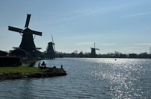
After around a half mile, start taking time to look behind you. Even though the hike doesn’t feel too steep, you’ll climb enough by this point to see some fantastic views of Barnaderg Bay. You’ll want to stop every few minutes to look back and see what new views the climb up the hill gives you.

The other main thing to see as you hike the lower loop is the peak of Diamond Hill gradually coming into focus. It’s a bare, rocky hilltop that is stunning in how much it sticks out in the boggy landscape.
Eventually, you’ll come to an intersection marked by a large vertical boulder. You can either turn left to continue to the upper loop, or keep straight to finish the lower loop. The rest of the lower loop is mostly a gradual descent through more boggy terrain. It’s barren land, yet quite attractive in its own way.
Upper Diamond Hill
Trail Stats
| Length | *4.2 miles |
| Elevation Gain | *1,348 feet |
| Time | *2.5-3 hours |
| Difficulty | Moderate but more strenuous near the top |
The Ascent
The lower lower loop is fun, but the star of this hike is the upper loop. It’s more challenging, with steeper inclines and some almost-rock scrambles but still manageable for most people. If you have mobility impairments, you may want to skip this loop because some of the trail towards the top gets a little treacherous. Another consideration is time. This loop almost doubles the distance of the lower loop and, because it is is also more difficult, takes a little longer to negotiate.
As long as time and mobility are not issues, you definitely should proceed to the upper loop!
Once you turn away from the intersection with the lower loop, the trail pretty quickly starts to get more steep. The tradeoff? The views of the bay behind you get even more impressive and the Twelve Bens start to come into focus ahead to your right. Make sure you take advantage of the many spots to stop and take in the scenery.
There is one intersection to watch out for where you have to turn left to proceed to the peak (again – remember that this trail is one way). You’ll encounter this intersection again on your way back down.
Before too long, you come to the difficult part of this hike. You’re almost at the peak, but first you have to negotiate some steep, rocky climbs. They aren’t quite what I would call a scramble. Still, they aren’t particularly easy and require your attention so you don’t lose your footing.
Personally, I found this section a lot of fun! It elevated this hike from a very good hike with great views to one of my favorite hikes of all time.

Other Content You Might Enjoy: A Detailed Guide to Dingle’s Slea Head Drive
Diamond Hill’s Peak
Once you’re at the peak, you’ll see why I said that the upper loop is the star of the hike. The views from here are simply astonishing. When I imagined what Ireland looked like before our trip, this was it. Clamber to the top of the boulders at the peak to really take in what nature has given us.
Every direction you look is remarkable. Down to your left is Kylemore Abbey and Pollacappul Lough. In front of you to the right are the Twelve Bens with a stream slowly cutting through the mountains on its way down into Polladirk Valley. Behind you are more views of Barnaderg Bay.
It’s all so remote, desolate and absolutely beautiful. While looking at these landscapes, I couldn’t help but imagine our distant nomadic ancestors roaming this land, still looking just as it did 2,000 years ago.


The Descent
After you’ve had your fill of these landscapes you can start making your way back down towards the lower loop. Nothing can beat the views from the peak, but I encourage you to take your time to observe the Polladirk Valley below from various angles and distances. This valley was my favorite part of the whole hike. There was just something about that stream as it wound its way through the mountains peaks and valley that was so majestic.
The hike itself as you come down from the peak is generally pretty easy. It is kind of steep initially, but asides from this it’s just a gradual descent. The main thing you need to look out for is sheep scat as there are sheep grazing through here.
You Might also Like: The #1 Guide for Hiking Old Rag in Shenandoah
After Your Hike
Once you’re done with your hike, check out the small town of Letterfrack for a quick meal. There’s a few dining options located around the main intersection in town. They all looked good and the smells emanating from Cloverfox Connemara in particular smelled great.
We wanted lighter fare so we walked across the road to Kabo Café. This café was a delightful little gem! Kabo’s is a cute little café with soup, sandwiches, burgers and various breakfast items. There are a few tables inside but these were closed to patrons when we visited due to COVID-19 restrictions. They do have outdoor seating weather permitting.
I had an open sandwich on sourdough bread with local goat cheese and salad. I’m not a big open sandwich fan but this was very good. The local goat cheese was especially excellent.

Other Things to do Nearby
Here are some suggestions for things to do near Connemara National Park if you are looking for more to do before heading back to Galway.
It bears noting that I did not visit any of these places myself. These recommendations are based on suggestions I found while either researching our trip or writing this article.
Clifden and the Sky Road
Ireland could be called the country of road trips, and here’s another worth checking out while you’re in Connemara. The start and end of the Sky Road loop is located in Clifden, the major town of the region. Along this route you’ll see sweeping views of Ireland’s west coast and get to drive near the ruins of Clifden Castle.
The drive itself is only 9.5 miles long. However, it will take about 20 minutes to get to Clifden from Connemara National Park.
Connemara Loop Drive
This is the other way to drive to the park that I mentioned earlier if you have extra time to see more of the local countryside before or after your hike. I would have loved to do this drive, but since we only had two days in Galway, we wanted to maximize our time in the city.
The 50-mile loop drive will actually take you past the two locations listed below and the park entrance. In addition to these, you’ll also see various archeological and historic sites, beaches, fishing villages, and other sights.
Learn more about the loop here.
Killary Fjord
Killary Fjord is one of only three glacial fjords in Ireland. The fjord is a short 15-20 minutes drive east from Letterfrack along N59 towards Leelane.
You can take a river cruise with Killary Fjord Boat Tours through the fjord for comfortable views of the local scenery from the water. Additionally, there is a greenway that runs along the fjord if you prefer to walk. The walkway will also take you through an abandoned famine village to see how locals lived during the potato famine.
Kylemore Abbey
If you’re driving from Galway, you’ll first spot Kylemore Abbey as you drive towards the park along N59. About three miles away from the park, you can see the abbey on the opposite side of a lake looking like a miniature Hogwarts. It’s a wondrous sight. Just make sure to be prepared and keep your eyes peeled because just as quickly as the abbey comes into view, it will disappear behind trees.
If the views from the road and Diamond Hill’s peak aren’t enough, you can purchase tickets to tour the abbey and its grounds. Visit the abbey’s website to book a tour.

Resources to Book Your Trip to Connemara
Whether you’re looking for tours, hotels or flights, here are some tools to help get you started planning your trip to Ireland!
Look for activities and tours offered through GetYourGuide or Viator!
Search Flights
Still can’t find what you’re looking for? Check out my travel essentials pages for more of my recommendations.
Pin This Post!


25 Comments
Retirestyle Travel
Ireland has such rustic beauty. Now, I know a great place to visit to see great views when I visit. Your information is always very helpful and detailed. I’d like to try the upper loop.
paulpassingthrough
Thanks – I really appreciate the feedback! If you visit County Galway you should definitely spend less time in the city and more time here. I was glad to see Galway, but in hindsight wish I had spent more time in the surrounding countryside.
Nyxie
The donkeys! Oh my days how cute.
These views remind me of walking the mountains at home. We have gorgeous mountainscapes here in Ireland, some of which are at my parent’s front door.
paulpassingthrough
The Irish are spoiled for gorgeous countryside. It was everywhere we went. Out of curiosity, what area do your parents live in? Just curious if I visited that area.
Molly Transatlantic Notes
Such lovely areas and sights to visit — thank you for sharing this beautiful part of the world!
paulpassingthrough
Thanks for visiting! It certainly is beautiful!
Mitch - VeryTastyWorld
Lovely post about a splendid hike. Those views really are spectacular – Ireland has the most amazing scenery. Funnily enough we visited Ireland in September and did the Connemara Loop Drive, which we really enjoyed. With you on the GPS – ours was a bit quirky at times, somehow calculating that the best route to a destination would be via the narrowest single track road it could find!
paulpassingthrough
Right! It’s almost like the GPS sometimes decides to calculate as the crow flies rather than how a car can actually get there. Next time I’m in Ireland I want to go back to spend more time in Connemara to do those drives and simply be.
Barry
Loved reading this, it brought back lots of fun memories. Those round-top mountains and vast open peatland scenes are just what I remember it to be.
I like the Trail Stats table you do, it gives at-a-glance important info. The info here is very detailed and I feel I am walking it with you. I am not a big hiker but the dialogue here certainly encourages me to think more about doing this, I tend to “hike” for hours in my city walks (with a different vista!).
I last went here many, many years ago with an Irish good friend, we had such a thrilling time driving the area and seeing all the sights. We stopped off at Kylemore Abbey and explored it. I boght a thick cream locally knit sweater there with Irish motives in the detail. It was signed on the label by the lady who knitted it – Mrs McHugh – I still remember the name, though the sweater has long since worn out,
paulpassingthrough
That’s a lovely story, Barry. I read about places in Ireland where you could watch the women knit these traditional Irish sweaters but I never saw any of them myself. You’re lucky to have at least had the chance to meet the knitter.
Britt K
This looks like a really beautiful hike. We’ve never been to the area but I’ll definitely have to check it out. Both my husband and I love searching out hiking trails everywhere we go.
paulpassingthrough
If you ever visit that region let me know and I can give some other recommendations!
Stephen & Andie
How beautiful! We’d LOVE to see Ireland in person and can’t wait until we can make it a reality. Also can’t wait to see more of it in your upcoming posts!
Kristen and Sam
What a great post! Ireland looks like a great place to visit!
paulpassingthrough
The whole country is gorgeous. I’ll be writing more about it after the holidays!
Fransic verso
This is amazing! the weather in there look really cool and just right for hiking!
paulpassingthrough
I wrote that in my journal actually. The weather imparted the perfect mood for this hike. Everything about it was very “Ireland.”
Eri
I love mountains and hiking. Ireland seems like a place I would enjoy traveling to for hiking. I will definitely add it in my list of countries I should visit.
P.s. the donkeys are adorable 💜
paulpassingthrough
We stopped to admire the donkeys for a solid several minutes lol After visiting I’ve been seriously thinking about becoming an ex-pat to move to Ireland!
Corinne
I’ve never been to Ireland before but it’s on my list for sure! There are so many beautiful places there. These hikes look fab.
paulpassingthrough
So true! Keep checking back; I’ll be posting more about Ireland over the next few months 🙂
Kelly Diane
Those donkeys are adorable. This post is packed full of so much helpful information. The views look incredible. I can see why it is a popular place for hiking.
paulpassingthrough
The donkeys were great lol I don’t know about for me but had the highlight of the hike been them I think my wife at least still would have been satisfied!
JoJo Hall
When I visited Ireland for a weekend trip back in 2015, I didn’t do any hikes because my friend and I were trying to see most of the country and some specific spots (Guiness factory and the Blarney Stone). When I eventually make it back to Ireland (if we can get over this COVID thing), I’ll definitely add this to my list for some awesome hikes!
paulpassingthrough
The Guinness Factory was one of my favorite things in Dublin! The floor with all the advertising history was so neat.